
In Rennes, the Vilaine is gradually regaining light after more than sixty years spent under a concrete slab. The city is completing the demolition of the old parking lot built in the 1960s.

HAS Rennes, the reconquest of the Vilaine enters its final phase. A 50 ton excavator installed on a floating pontoon demolishes the last vestiges of parking lot built in the 1960s above the river. Behind this extraordinary 29 million euro project, the metropolis intends to restore its place to water in the city center and create an important island of freshness to face global warming.
Inaugurated in 1963 under the municipality of Henri Fréville, the structure was designed to respond to the lack of parking spaces in the Rennes hyper-center. The concrete slab, 270 meters long, then covered part of the Vilaine, the appearance of which was considered unappealing at the time. More than sixty years later, this emblematic “all-automobile” infrastructure is dismantled in order to restore its place to the river and adapt the city center to current climate issues. A demolition which perfectly illustrates the evolution of urban policies between the 1960s and today. © Sigismond Michalowski
The construction site that erases the heritage of the automobile city
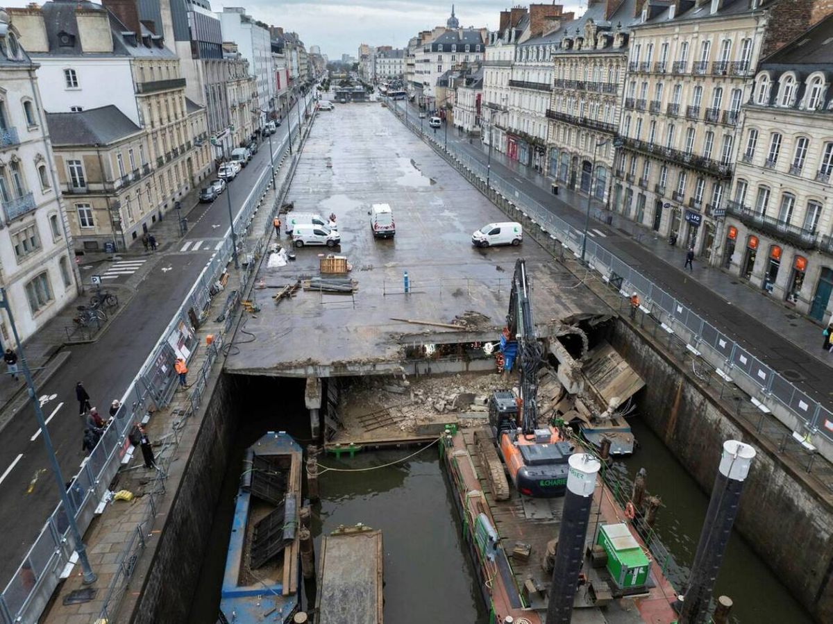
Every day, the same spectacle is repeated in the heart of Rennes: installed on a floating barge, a 50-ton excavator methodically nibbles away at the concrete slab covering the Vilaine for over sixty years. The objective is now to demolish around five meters per day, between the Pont de la Mission and the rue de Nemours, near the Galeries Lafayette.
The Vilaine car park in Rennes, located between the Duguay Trouin and Lamennais quays, after its closure on September 1, 2025. © Hoolen / Wikipedia
The first phase of this extraordinary project is now coming to an end. The two kiosks in the old parking lot have already disappeared and the last meters of concrete are being demolished. Built in 1963, at a time when the automobile shaped city centers, this infrastructure covered nearly 6,600 m2 of the river over 270 meters in length and accommodated nearly 300 parking spaces in the heart of the city center.
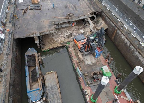
The operation represents a considerable logistical challenge because in total, 6,000 tonnes of concrete and 1,000 tonnes of bitumen must be evacuated. The rubble is gradually loaded onto barges then transported to a recycling site located on Route de Lorient, thus limiting heavy goods vehicle traffic in the city center. © David Ademas / Ouest-France
During a visit to the site, the mayor of Rennes, Nathalie Appéré, recalled:climate ambition but also the desire to beautify the city” which underlie this major transformation of the urban landscape.
Transforming the heart of Rennes into an island of freshness
Once the demolition phase is completed, a second project will take over until mid-2028. The objective is not only to make the Vilaine visible againbut to completely reinvent the banks of the river.
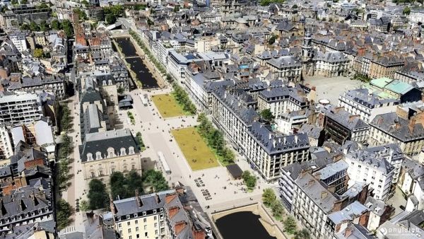
Perspective of the overall project. From spring 2026 until summer 2028, the reinforcement of the slab which structures Place de la République, the development of public spaces and the construction of structures on and around the water will take place in phases. © Phytolab
According to the projections mentioned by Nathalie Appéré, Rennes could experience climatic conditions comparable to those of Toulouse today by 2050. In this context, the reopening of the river and the strengthening of vegetation appear to be essential adaptation tools. In addition, the removal of parking would not have affected the attractiveness of the city center since the mayor assures that the GPS data does not show “no impact on city center attendance“despite the disappearance of several hundred parking spaces. And some local residents are already looking forward to taking advantage of a “nice view of the river“.
At the end of the demolition work, the site will accommodate several new developments intended to reinforce pedestrian continuity and to re-establish a direct link with La Vilaine. A footbridge reserved for pedestrians will notably be built in theaxis of rue Lanjuinais in order to facilitate river crossings and improve connections between the two banks. Two stands will also be set up on either side of the open area, near Place de Bretagne and the Pont de Nemours. Designed as gazebos overlooking the Vilainethey will offer unobstructed views to the east and west. On the Duguay-Trouin quay, floating pontoons accessible by a ramp and a staircase currently hidden by the car park will allow users to get closer to the watercourse, while several floating gardens will complete the landscaping.
The north platforms will be completely reconfigured to integrate the Réseau Express Vélo (REV) and a continuous pedestrian promenade. Cyclist and pedestrian flows will be separated thanks to landscaping combining trees and vegetation. Car traffic will be maintained according to the cycle street principle, guaranteeing access to local residents and delivery vehicles while giving priority to active mobility. On the Lamartine quaythe separation between the pedestrian paths and the cycle path will be materialized by a physical border in order to make travel safer.
On the south bank, facing the Museum of Fine Arts, a corbel will be built above the Vilaine in order to widen the sidewalk of Quai Zola. This extension will make it possible to absorb the expected flows around the future Trambus station as well as improve traffic conditions for users.
The Palais du Commerce sector will also benefit from a major requalification. The Joffre square, currently occupied by several bus stops, will be transformed into an open public space favoring pedestrian crossings and uses. At the same time, the rue du Pré-Botté will be completely redeveloped to accompany the opening of the Palais du Commerce to the south. This route will become mainly pedestrian while retaining essential access for local residents, deliveries, waste collection services and emergency vehicles.
The operation will finally be accompanied by an important environmental component with the planting of 184 trees and the creation of more than 5,000 m2 of vegetated or de-waterproofed spaces, with the triple objective of:
– reinforce the infiltration of rainwater;
– Limit urban heat island effects;
– And sustainably improve the climatic comfort of the city center.
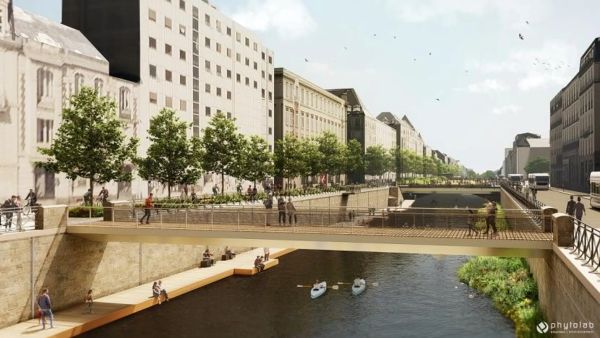
Perspective of the future footbridge in the extension of rue Lanjuinais, pontoons and floating gardens to the west of the project. © Phytolab
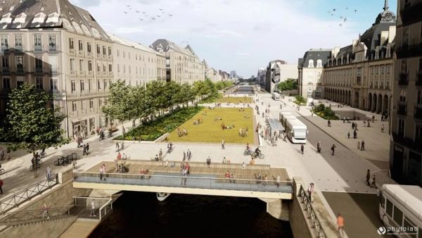
Place de la République is directly integrated into the structures which cover the Vilaine. Built in 1912, the République slab now requires major intervention, the diagnostics carried out having highlighted the need to rehabilitate its structure in order to guarantee its sustainability. At the end of the work, the square will be the subject of a complete redevelopment: the project includes the creation of large raised lawns, laid out on a gentle slope and lined with stands, as well as the planting of trees along the Lamartine quay. © Phytolab
David Ademas / Ouest-France